


A platform that encourages healthy conversation, spiritual support, growth and fellowship

NOLACatholic Parenting Podcast
A natural progression of our weekly column in the Clarion Herald and blog

The best in Catholic news and inspiration - wherever you are!
Fox 8’s Shelby Latino: The La Niña-El Niño neutral ground
-
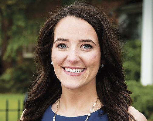
(Photos courtesy of Shelby Latino)
In this interview with the Clarion Herald, Fox 8 WVUE-TV meteorologist Shelby Latino analyzes the upcoming hurricane season.Q: What are the experts expecting?
A: The experts are forecasting a slightly above-average season. But one thing that’s working in our favor a little bit – and I don’t want to be overly optimistic about this – the ending of La Niña is a big deal. La Niña tends to fuel Atlantic storms more. An El Niño year would be great, but we’re in what’s described as an in-between state, which is better than being in La Niña but not quite as good as being in El Niño.
Is it still true that predictions of a hurricane’s track are much better than predictions of its intensity?
That is absolutely the case. Track forecasting has come a long way in the last decade and a half; intensity forecasting has also come a long way, but it’s still not quite there, as we saw several times last season with the rapid intensification that we see over those warm one Gulf waters. That can really be problematic.
What was last year like for you when it seemed as though almost every week or so we were in the cone?
Marco and Laura were those two storms that everybody was making a big deal out of. Technically, Laura made landfall before Marco was truly an issue. But I recall that being about a week and a half of straight, constant coverage of possibilities along the Louisiana coastline.
What are the indicators that you look at in a hurricane forecast?
We are partners with the National Weather Service and the National Hurricane Center. We absolutely work with them and trust their forecasts. But we are also meteorologists ourselves. Sometimes I disagree with the National Hurricane Center, but never by much. I tend to stay very close to the National Hurricane Center, but if I think there’s a risk of that storm going outside the cone for some reason or if I think there’s a risk of it strengthening more rapidly, I’ll absolutely say so. Some of the things I look for are water temperatures – and not just sea-surface temperatures – because the depth of the warm water matters a lot. And then I also look at wind shear, because that’s what can help really tear a storm apart or slow a storm down. I also look at high and low pressure systems that may help with the steering of the storm.
What improvements have been made to hurricane forecasts?
In the last couple of years, we’ve introduced some new satellites, and those have been really helpful, but sometimes it can take years of analyzing new data to really make the forecasts better. The American model (the Global Forecast System or GFS) just recently got a big upgrade, and the hope is that it will perform better during hurricane season, although I found that in many situations last season, the American model was (already) performing better than the European model. Those models make different assumptions about the atmosphere. Prior to this upgrade to the American model, the biggest difference was the resolution and the amount of computing power going into the model. The European was actually much higher quality in resolution and in its ability to take more things into account – more equations, fewer assumptions. With the GFS upgrade, I am hopeful we’ll have higher resolution and better forecasts.
Do you worry about the public being jaded after so many near-misses?
Preparing and taking each storm as it comes – seriously but not overreacting – is so important. It’s really important that folks try to listen to what the meteorologists are saying and take a deep breath. Not every storm is going to be the same; it’s not always going to be the worst-case scenario. So letting your mind go to that anxious place is not necessarily a good thing. Just try to just make sure you’re prepared, and you’re ready to go when we say it’s time to go.
Sometimes it seems national experts tend to go heavy on the drama when a hurricane approaches.
I can’t stress enough, if it’s coming here, turn off The Weather Channel, because your local meteorologists know the area better. If you’re just looking for general weather about what’s going on around the U.S., fine, but if you’re looking for what’s going on around here, your local meteorologists know the area. We know how to pronounce your towns, and we have a pretty good idea of what these storms are doing, too. Just listen to us. We’re not trying to scare you. We live here. We know what we’re doing with our families, and I’ll even say that on air: “I’m sending my daughters out of town for this” or “We’re going to be sheltering at home.” We have a little more stake in the game than the national folks.
On a personal note, you announced recently on air that you and your husband are expecting triplets!Yes, I’m expecting in early to mid-September. The way the doctor explained it to me is that’s my due date, but there’s no way these babies are going to full-term. We planned a late-October baby, but now these are going to be peak-of-hurricane-season babies!
– Interviewed by Peter Finney Jr., Clarion Herald